THE CONSTRUCTION INDUSTRY’S NATIONWIDE DRONE SERVICE PROVIDER
SAVING GCs AND STAKEHOLDERS TIME AND MONEY WHILE CREATING A SAFER WORK ENVIRONMENT
THE CONSTRUCTION INDUSTRY’S NATIONWIDE DRONE SERVICE PROVIDER
SAVING GCs AND STAKEHOLDERS TIME AND MONEY WHILE CREATING A SAFER WORK ENVIRONMENT
Welcome to Drone Brothers!
Drone Brothers is the leading provider of nationwide drone services to many of the largest and most respected construction firms in the industry. Headquartered in Michigan, our suite of GC specific services includes aerial photos, videos, mapping, a wide range of analytics, detailed inspection analysis and video content for multiple social media and marketing platforms. With over 350+ Part 107 licensed pilots, we specialize in drone services for the construction space. Offering services for all stages of the construction process – from site selection to project close-out – you are always a single click away from all your project assets, across multiple projects nationwide.
Drone Brothers Updates

Project Diehard: 1.2 Million-Square-Foot Industrial Development.

Atwell LLC | Sun Resorts & Residences Fort Myers Beach (Indian Creek).

Contegra Construction Patriot Highway Industrial Development.

Teichert Construction Highway 101.

Aristeo West Jefferson Energy Storage Project.

Drone Brothers Documents Progress at the New Cody High School in Detroit

Welcome to the Team: Jet Rafael Joins Drone Brothers as Senior Software Engineer
")
Sterling VA: Pinstack Kincora Drone Services & Volumetric Analysis.

Fort Wayne: Parkview – Raytheon Aerial Photography for CRE.

Parkview Warehouse: Commercial Aerial Imagery by Drone Brothers.

Sarasota Construction Drone Photography: Fruitville Charter School.

Welcoming Our Summer Interns to the Drone Brothers Team.

Schafer Construction Breaks Ground for Agape City Church.

Welcoming Schafer Construction to the Drone Brothers Family.

Inside Waste Management’s New $60M Recycling Facility in Indianapolis.

Drone data is saving millions on construction projects.

VAYA on Axia Apartments in Chula Vista, California.

Why Ground Control Points Matter.

Costco Distribution Facility Taking Shape in Sacramento, CA.

Leadership & Trust in AI Transformation | Andrew Wolfe Interviews Tasha Poduska | DBR Ep.11
Explore our latest nationwide projects
COMPLETED JOBS
IMAGES PROCESSED
FLIGHTS
%
CUSTOMER SATISFACTION
PROGRESS PHOTOS & VIDEOS
Progress photos and videos help document all phases of construction over time and keep your stakeholders, investors, owners, GC’s, subs, clients, banks, insurance companies and municipalities updated.
SITE SELECTION
Rather than looking at outdated Google Maps, drone pilots are able to fly a prospective site without you having to leave the office while still getting a detailed, up-to-date view of the property your considering for your next job site.
JOBSITE MAP PRINT OUTS
While our job site maps are all available digitally, many prefer to roll out a map. Cover the walls in the job trailer with weekly maps we create so you can see your job progress come to life.
LEGAL DOCUMENTATION
By creating a map or doing a video flyover, we can document the conditions of the roads before your trucks and heavy equipment show up.
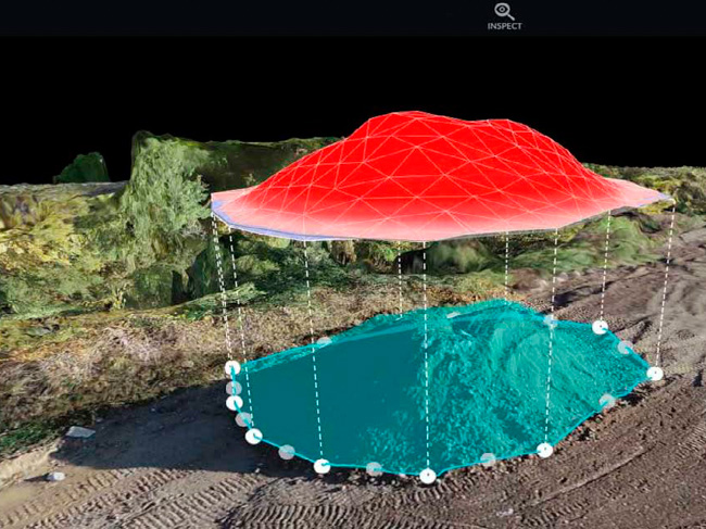
STOCKPILE MEASUREMENTS
Want to know how many trucks you will need to haul away the piles of crushed concrete on your job site? Our stockpile measurement technology is a game changer.
Façade Inspections
Safely, efficiently and quickly conduct façade inspections with the help of our expert drone pilots and visual mapping services.
Site Monitoring
Monitor all the action happening at your site with up-to-date drone photos and videos from all the key angles in the sky and on the ground.
Integrations
Integrate with all of your technologies including ProCore, AutoCAD and much more. We'll help you streamline the use and sharing of drone assets.
Ground Control Points
Add Ground Control Points (GCPs) to any site to capture pinpoint accuracy and analyze your job site progress from the large scale to the minuscule.
Zoning Meetings
Rather than waiting for the zoning board to send someone out to visit your site, be proactive and bring the site to them.
Site Plan Overlays
We can import your site plan as a separate layer in our drone maps or we can export our contour maps for use in your CAD system.
Groundbreaking
Drones make for a great tool to capture your team, your client and local government official with their hard hats and shovels for the groundbreaking ceremony.
360 Rendering Video
We can provide drone footage of empty land and overlay a 360 model of your new building as if it already exists.
Cut Fill Analysis
Our team can help with Cut-Fill analysis to help you save considerable time and money.
Milestones
Drones are an outstanding tool to capture various milestones of your project; Footings placed, wall tilts, cement pours, roof placement, top off ceremonies and more.
Facade & Roof Inspection
The results of an aerial inspection offers our clients a way to safely present a more fully developed scope of work.
Interior Captures
We capture interiors with a drone fly through; great for large scale warehouse type projects (100,000’+) as well as more detailed FPV (First Person View) tour.
360 Interior Captures
Our team can do a complete walk through with our 360-degree cameras, delivering incredible detail utilizing the world’s most flexible and easiest-to-deploy 3D digital twin platform.
System Training Videos
With our nationwide team of pilots and videographers, we can help capture and produce system training videos for you to hand over to the new owners.
Documenting "As Built"
Compare what was built with the plan and make sure they fit together.
Day in the Life Video
Every business has a story to tell. Let Drone Brothers Marketing team help tell your companies story.
Final Landscape Shots
The photos and videos that we capture will give you and your clients some spectacular images to use in all your marketing and social media.
Project Time Lapse
Time lapses are a great way to show off your work, WOW existing clients and show prospective clients the caliber of your work.
Final Project Tour
Highlight the years of hard work your company invested in order to complete a building.
Building INSPECTIONS
Safely, efficiently and quickly conduct building inspections with the help of our expert drone pilots and visual mapping services.
PROGRESS PHOTOS & VIDEOS
Progress photos and videos help document all phases of construction over time and keep your stakeholders, investors, owners, general contractors, subs, clients, banks, insurance companies and municipalities updated.
SITE SELECTION
Rather than looking at outdated Google Maps, drone pilots are able to fly a prospective site without you having to leave the office while still getting a detailed, up-to-date view of the property your considering for your next job site.
LEGAL DOCUMENTATION
By creating a map or a video flyover, we can document the conditions of the roads before your trucks and heavy equipment show up.
BUILDING INSPECTIONS
Safely, efficiently and quickly conduct building facade inspections with the help of our expert drone pilots and visual mapping services.
JOBSITE MAP PRINT OUTS
While our jobsite maps are all available digitally, many prefer to roll out a map. Cover the walls in the job trailer with weekly maps we create so you can see your job progress come to life.
STOCKPILE MEASUREMENTS
Want to know how many trucks you will need to haul away the piles of crushed concrete on your job site? Our stockpile measurement technology is a game changer.
Ground Control Points
Add Ground Control Points (GCPs) to any site to capture pinpoint accuracy and analyze your job site progress from the large scale to the miniscule.
Integrations
Integrate with all of your technologies including ProCore, AutoCAD and much more. We'll help you streamline the use and sharing of drone assets.
Site Monitoring
Monitor all the action happening at your site with up-to-date drone photos and videos from all the key angles in the sky and on the ground.
Site Plan Overlays
We can import your site plan as a separate layer in our drone maps or we can export our contour maps for use in your CAD system.
Groundbreaking
Drones make for a great tool to capture your team, your client and local government official with their hard hats and shovels for the groundbreaking ceremony.
Milestones
Drones are an outstanding tool to capture various milestones of your project; Footings placed, wall tilts, cement pours, roof placement, top off ceremonies and more.
360 Rendering Video
We can provide drone footage of empty land and overlay a 360 model of your new building as if it already exists.
Zoning Meetings
Rather than waiting for the zoning board to send someone out to visit your site, be proactive and bring the site to them.
Cut Fill Analysis
Our team can help with Cut-Fill analysis to help you save considerable time and money.
Documenting "As Built"
Compare what was built with the plan and make sure they fit together.
360 Interior Captures
Perform complete walk through with our 360-degree cameras, delivering incredible detail utilizing the world’s most flexible and easiest-to-deploy 3D digital twin platform.
System Training Videos
With our nationwide team of videographers, we can help capture and produce system training videos for you to hand over to the new owners.
Interior Captures
We capture interiors with a drone fly through; great for large scale warehouse projects (+100k ft) as well as more detailed FPV (first person view) tour.
Façade Inspections
The results of an aerial inspection offers our clients a way to safely present a more fully developed scope of work.
Day in the Life Video
Every business has a story to tell. Let Drone Brothers Marketing team help tell your companies story.
Final Project Tour
Highlight the years of hard work your company invested in order to complete a building.
Project Time Lapse
Time lapses are a great way to show off your work, WOW existing clients and show prospective clients the caliber of your work.
Final Landscape Shots
The photos and videos that we capture will give you and your clients some spectacular images to use in all your marketing and social media.
WE WORK WITH THE BIGGEST NAMES IN CONSTRUCTION
Get a quote on your construction project today!
WHY DRONE BROTHERS?
Professionals
Besides loving to fly drones, we know how to run a business and how to treat customers. You will never wait on hold or wait days for a call back!
Nationwide
Base in Troy, Michigan, we have built a NATIONWIDE network of pilots, editors and experienced map makers. Think of us as a one stop shop for all your drone needs.
Insured
We carry a $2 Million dollar liability policy on all our drones. No matter how large the project, you can rest easy knowing that we have you covered.
FAA Part 107
5-Star Reputation
For us cutting edge drone technology is just as important as answering the phone and helping our customers make the most of our services.
Technology
We utilize top-of-the-line drone technology and software and are always looking for ways new tech can be used to help our clients.
WHY DRONE BROTHERS?
5-Star Reputation
For us cutting edge drone technology is just as important as answering the phone and helping our customers make the most of our services.
Technology
We utilize top-of-the-line drone technology and software and are always looking for ways new tech can be used to help our clients.
Professionals
Besides loving to fly drones, we know how to run a business and how to treat customers. You will never wait on hold or wait days for a call back!
Insured
We carry a $2 Million dollar liability policy on all our drones. No matter how large the project, you can rest easy knowing that we have you covered.
FAA Part 107
Nationwide
Base in Troy, Michigan, we have built a NATIONWIDE network of pilots, editors and experienced map makers. Think of us as a one stop shop for all your drone needs.
BENEFITS OF WORKING WITH DRONE BROTHERS…
WORK
SAFER
Drone photography, videography and mapping services allow you to review building facades, elevated structures and more without the need for a person to physically assess these structures.
WORK
SMARTER
Manage your construction job sites with more efficiency utilizing the powerful, realtime visual assets and maps we capture for you.
WORK
FASTER
We’ve developed a process that makes accessing, viewing, sharing and downloading photos, videos and maps simple, helping you make decisions faster. Plus with a nationwide network of pilots onboarding with us is a breeze.