Ground Control Points
Ground Control Points
In the world of construction, time is money. Anything that can help save time while improving accuracy and efficiency is a valuable tool to have in your arsenal. That’s where Ground Control Points (GCPs) come in. By adding GCPs to a construction site, you can capture pinpoint accuracy and analyze job site progress from the large scale to the minuscule, creating efficiencies that can save time and money in the long run.

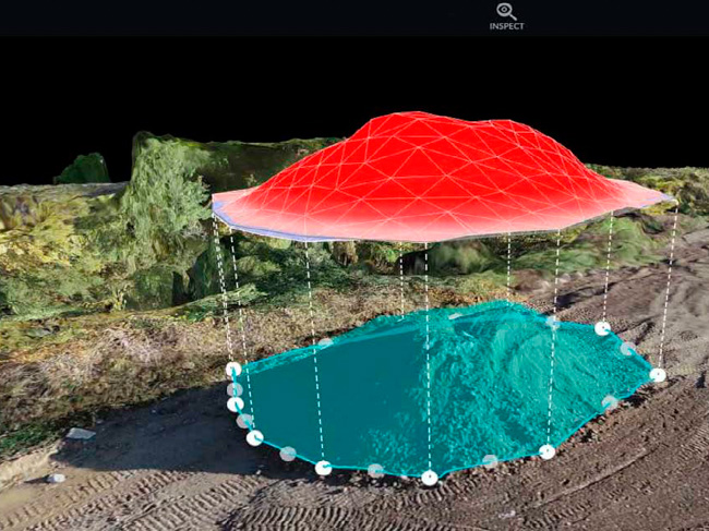
GCPs are physical markers placed at specific locations on a job site. They serve as reference points for aerial imagery captured by drones or other aerial surveying tools. By accurately measuring the location of these markers on the ground, and then factoring in their position in the aerial imagery, you can create highly accurate maps and models of the job site.
One of the key advantages of GCPs is their ability to provide accurate measurements of a construction site, even when the terrain is uneven or complex. This is especially important for large-scale projects, such as highway construction or building a new industrial complex. Without accurate measurements, it can be difficult to determine the exact location and size of objects on the job site, leading to errors and delays.
GCPs can also help construction managers keep a close eye on the progress of a project. By capturing up-to-date aerial imagery of the job site, they can quickly identify areas that need attention or where work is falling behind schedule. This can be especially helpful in identifying potential safety hazards, such as uneven terrain or unstable structures.
Another advantage of using GCPs is the ability to create highly detailed 3D models of the job site. These models can be used to plan out the placement of equipment, materials, and workers, helping to optimize the layout of the job site and increase efficiency. They can also be used to identify potential conflicts or problems before they arise, saving time and money in the long run.

One of the most significant benefits of using GCPs is the ability to track progress over time. By comparing aerial imagery captured at different points during the construction process, construction managers can track how much progress has been made and identify areas where work is falling behind schedule. This can help them make more informed decisions about resource allocation and scheduling, helping to keep the project on track and within budget.
GCPs can also be used to improve safety on the job site. By accurately mapping the terrain and structures, construction managers can identify potential hazards and take steps to mitigate them. For example, they can identify areas where workers may be at risk of falling or where heavy equipment may be at risk of tipping over. This can help reduce the number of accidents and injuries on the job site, improving safety for everyone involved.

Finally, GCPs can be used to improve communication and collaboration among the various teams working on a construction project. By providing accurate and up-to-date aerial imagery of the job site, everyone involved in the project can get a better understanding of the progress being made and the challenges that need to be addressed. This can help foster collaboration and communication, leading to a more efficient and effective construction process.
In conclusion, adding Ground Control Points to a construction site can provide a wide range of benefits, from improving accuracy and efficiency to enhancing safety and collaboration. By capturing pinpoint accuracy and analyzing job site progress from the large scale to the minuscule, construction managers can make more informed decisions, optimize resource allocation, and keep the project on track and within budget. Utilizing Drone Brothers aerial surveying tools, adding GCPs to your construction site has never been easier or more cost-effective. It’s a valuable tool that every construction manager should consider using to improve the success of their projects.
Let’s Get Started
Call Now
If you have any questions, please call us at 248.763.0870.
Schedule a Call
If you would like to schedule a call to discuss uses and service options, schedule a call.
Get Started
Continue to our Pre-Flight Questionnaire and receive a quote for services.
Free Training
Continue to schedule a free in-person or virtual training session or ‘Lunch & Learn’ for you and your team.