MAPPING ANALYTICS
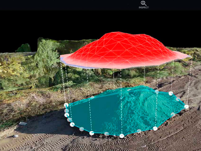
STOCKPILE MEASUREMENTS
Our stockpile measurements and comprehensive analytics are a game changer. Drone Brothers can help you streamline surveying, estimating and reporting. Combined with our advanced digital platform, we can provide you with the data needed to accurately measure earth moving needed to reach finished grade. Helping you win bids, keep projects on schedule, and the entire project team updated on progress.
SITE PLAN OVERLAYS
Site plan overlays are the perfect way to check progress. Drone Brothers will import and overlay your site plan, which allows you to quickly check progress against plan drawings, including grading vs. actual elevation, spotting health and safety issues, annotating delivery route planning, and many other use cases. With site plan overlays, you will be able to identify problems and issues before they become costly, saving valuable time, money and resources.
HIGH-RESOLUTION ORTHOMOSAIC IMAGES
Even after 10 years of doing this, we remain amazed at how powerful these high-resolution, orthomosaic maps and images can be. They say an image is worth 1,000 words and we agree. We capture your entire job site in one photo that allows you and your team to easily zoom in and out, visually telling the story of your project better than any email or phone call. Our high-resolution images are invaluable to your team and all stakeholders.
COMPARE SLIDER
With this feature you can easily select dates from two different maps and compare progress between time frames. This is the perfect tool for when you need to look back and compare last month to this month, or last week to this week and visualize progress in real time. This remarkable, simple to use tool also keeps all stakeholders up to date on the progress of the job site.
EARTHWORK & CUT/FILL
Our mapping software makes it easier and faster than ever to accurately measure earth moving needed to reach final grade. Helping you win bids, keep projects on schedule, and the entire team updated on progress. The best part is we can capture and process accurate drone-based elevation data in a matter of hours, saving your team valuable hours and money.
MAPPING TOOLBOX
Our mapping software is remarkably versatile. Here are a few examples… With the push of a button, you can easily drop a marker on the map and leave a simple identifier naming the issue, add an observation such as the severity of an issue and even add an estimate for the cost of the repair. Or you can calculate down to the inch the distance between any two objects within minutes. Or you can easily click on and count objects around your site. Or you can realize an accurate stockpile measurement within minutes, eliminating days or weeks to get your results back.
3D MODEL VIEW
At the bottom of our traditional 2D orthomosaic maps are three icons. Simply select the middle one (model), and our software will build out a 3D model right before your eyes. Not only will this give you an outstanding way to view your site, but you can also export and share.
EXPORTS AVAILABLE
Using the export option from our mapping software, with the push of a button, your team can easily export files to use in Procore, Bluebeam, Revit or any other CAD software. From a simple PDF or JPG, to more complicated Point Cloud, DTM’s and 3D models, all of these exports are FREE and available to you anytime from a secure single source location.
FACADE INSPECTIONS
Drones are instrumental in inspection of facades and roofs. The use of drones has several benefits over traditional methods, including increased safety, improved efficiency, and more accurate data collection. In this blog post, we will explore how drones can be used for façade and roof inspections and the advantages of using drones over traditional inspection methods.
PRINTED SITE MAPS
Even though our drone maps are all easily shareable electronically, paper maps are a favorite of our clients. Our successful clients cover the walls in their job trailer with weekly maps we have created. The trades love this! They can walk up to the wall and see weeks or months of construction progress photos. No more arguing over why the “site is a mess and needs to be cleaned up” or “this is where the roofing material needs to go when it arrives next week”.