

In the world of construction, accurate measurements and calculations are essential for creating precise and reliable decisions. With the advancements in technology, mapping software has revolutionized the way construction professionals work. In this article, we will explore the various measurement and calculation tools now available in drone mapping software.
Location Marker Tool: Pinpointing with Precision
One of the fundamental tools in this mapping software is the location marker tool. This tool allows users to effortlessly drop pins on the map with a single button push. Not only does it enable users to mark specific points, but it also allows for the addition of simple identifiers to represent different locations. Whether you’re marking important landmarks, specific areas of interest, or plotting a route, the location marker tool ensures precision and ease of use.
Distance Measuring Tool: Calculating Distances with Accuracy
Accurate distance measurement is crucial in construction projects. The distance measuring tool in this software simplifies the task of calculating distances between any two objects or locations on the map. With just three mouse clicks, users can obtain precise measurements down to the inch. Whether it’s determining the distance between two landmarks or calculating the length of a road, this tool provides the accuracy and efficiency required for construction.
Determining Fence Line Perimeters: A Seamless Process
Mapping software’s distance measuring tool proves to be incredibly useful in determining fence line perimeters. With a single mouse click, this tool provides the exact length of any enclosed area. This feature is particularly valuable for measuring distances accurately. Instead of relying on manual measurements, this tool streamlines the process and delivers precise results effortlessly.
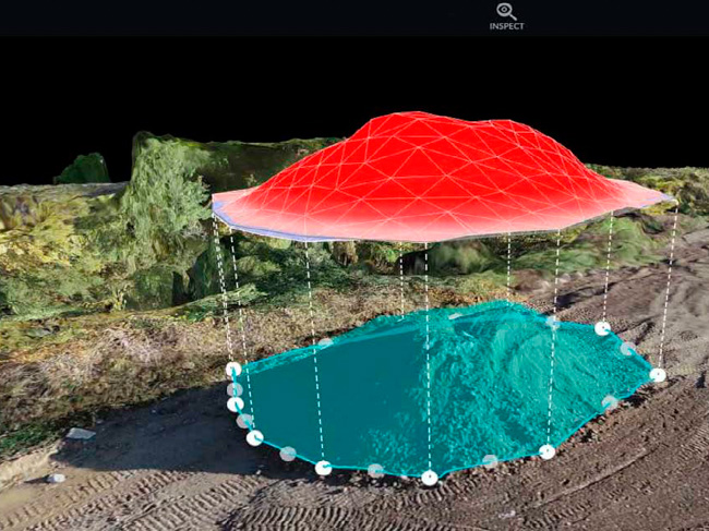
Stockpile Volumetrics Calculations: Efficiency at its Best
One of the standout features of this mapping software is the stockpile volumetrics calculations tool. Traditionally, measuring stockpiles would require days or even weeks for surveying teams to manually perform the calculations. However, with this software, accurate volume measurements can be obtained within minutes with just a few clicks. This tool not only saves time but also ensures precision, making it a favorite among users.
Counting Pointer: Effortless Object Counting
Another impressive tool showcased in this mapping software is the counting pointer. This feature allows users to easily click and count objects around a specific site, all from the comfort of their desk. Imagine being able to count 100 trees planted around a perimeter, providing proof of fulfillment for a city requirement. The counting pointer tool simplifies such tasks and eliminates the need for manual counting, saving time and effort.
Issue Tracking: Streamlining Communication
Efficient issue tracking is crucial in any project, and this mapping software offers a seamless solution. The issues button enables users to drop a location pin for any issues, name the issue, add observations, mark the severity level, and even include a cost estimate for repairs directly from the map interface. This feature ensures effective communication and streamlines the process of addressing and resolving issues. Whether it’s identifying road damages or noting construction flaws, the issue tracking tool proves to be invaluable.
Conclusion
The mapping software discussed in this article provides a wealth of measurement and calculation tools, each designed to simplify and enhance the work on any construction project. From the location marker tool for pinpointing specific points to the distance measuring tool for accurate calculations, this software offers a comprehensive suite of features. The stockpile volumetrics calculations tool revolutionizes the process of measuring stockpiles, while the counting pointer allows for effortless object counting. Lastly, the issue tracking tool streamlines communication and enhances project management. By utilizing these innovative tools, professionals can achieve quick and precise results without the need for extensive fieldwork or manual calculations. Embrace the power of mapping software and unlock a world of possibilities in your mapping endeavors.

0 Comments