

In the world of construction, staying ahead of the game is essential. With new technologies constantly emerging, construction teams must embrace innovation to streamline processes and improve overall efficiency. One such technology that is making waves in the industry is Orthomosaic Mapping Analytics from Drone Brothers. This revolutionary mapping tool is set to completely transform the way construction projects are managed and executed. In this article, we will explore the key features and benefits of Orthomosaic Mapping, and how it can revolutionize the construction world.
A Top-Down View
Orthomosaic Mapping provides project managers and superintendents with a unique top-down view of the entire construction site. By utilizing aerial drone footage or satellite imagery, this technology allows for a comprehensive and detailed mapping of the site from above. This bird’s-eye view provides a wealth of information that can greatly enhance decision-making and planning processes.
High-Resolution Site Maps
With Orthomosaic Mapping, teams have access to a high-resolution site map right from the home screen. This detailed map offers an overhead view of the layout of the site and its structures. By having this comprehensive visual representation, construction teams can easily navigate through the site and gain a better understanding of its overall structure.
Panoramas and Photo Tours
Drone Brothers Orthomosaic Mapping also offers the ability to view panoramas and take a photo tour of the construction site. Panoramas provide 360-degree views from specific locations, allowing project managers to get a complete picture of the site from different perspectives. Additionally, the photo tour feature allows for a series of geotagged photos that document the site, providing an invaluable visual record of the construction progress.
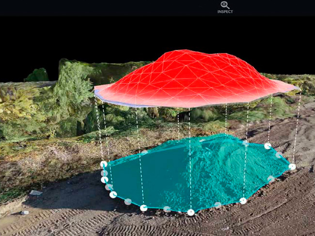
Powerful Measurement Tools
One of the standout features of Drone Brothers Orthomosaic Mapping is the availability of useful measurement tools directly within the mapping interface. This means that distances, areas, volumes, and other metrics can be easily calculated for site components directly on the map. These measurement tools enable construction teams to accurately assess quantities and dimensions, leading to more precise planning and resource allocation.
Shareable Data and Analytics
Drone Brothers Mapping Analytics makes it easy to share data and analytics with project stakeholders. All the valuable information gathered from the mapping process can be exported in various formats, allowing for seamless communication and collaboration. This ensures that everyone involved in the project has access to the most up-to-date information, fostering transparency and efficiency.
Secure Cloud Storage
All data collected through Drone Brothers Orthomosaic Mapping Analytics is securely stored in the cloud. This means that the information is accessible from any internet-connected device, eliminating the need for physical storage and ensuring that it is always backed up remotely. This cloud-based approach provides peace of mind and simplifies data management, allowing for easy retrieval and analysis.
Timeline Feature for Historical Tracking
Drone Brothers Orthomosaic Mapping Analytics offers a unique timeline feature that allows users to easily view past versions of the map. By simply clicking a button, project managers can navigate backward in time and see how the site has evolved over the course of the construction project. This historical tracking feature provides invaluable insights into the progress and changes that have occurred, facilitating comprehensive project management and documentation.
Conclusion
Orthomosaic Mapping Data from Drone Brothers is a groundbreaking technology that offers construction teams an integrated aerial mapping solution with powerful measurement and analytics tools. This innovative tool provides a centralized and shareable record of the construction site, allowing for efficient collaboration and decision-making. Furthermore, the ability to track changes over time provides a valuable historical perspective that can greatly enhance project management. According to the video, this new technology has the potential to save clients thousands in costs and hours, while also improving safety.
With its top-down view, high-resolution site maps, panoramas, measurement tools, shareable data, secure cloud storage, and timeline feature, Orthomosaic Mapping Analytics from Drone Brothers truly is a game changer for the construction industry. By embracing this innovative technology, construction teams can streamline processes, reduce costs, and improve overall project outcomes. So, it’s time to take flight with Drone Brothers and experience the future of construction project management.

0 Comments