

In today’s fast-paced construction industry, time is money. Construction companies are constantly looking for innovative ways to streamline processes, increase efficiency, and ultimately, win more bids. That’s where drone mapping software comes in. This revolutionary technology is changing the game when it comes to earthwork site balancing and cut/fill analysis.
Benefits of Drone Mapping Software
Imagine being able to accurately measure earthworking needs and reach final grade with ease and speed. That’s exactly what drone mapping software offers. Gone are the days of relying on traditional surveying methods that can be time-consuming and expensive. With the help of Drone Brothers, construction companies can now capture and process accurate aerial data in just a few hours.
Time and Cost Savings
As anyone in the construction industry knows, time is of the essence. Delays can cost money and impact project schedules. That’s why having tools like drone mapping software is essential. By utilizing this technology, construction companies can save valuable time and resources on job sites.
Accurate Data and Reporting
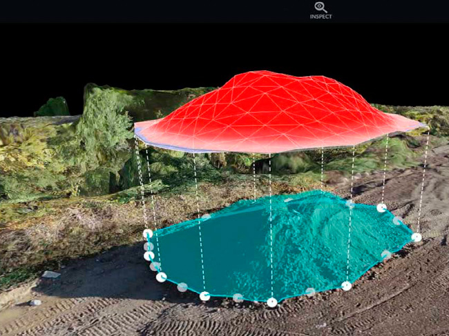
Drone mapping software from companies like Drone Brothers is at the forefront of aerial mapping technology. With their software, construction managers can access detailed cut/fill reports and 3D visualizations of job sites. This allows them to precisely understand how much soil needs to be moved to reach final grades across a site.
The importance of accurate site measurements cannot be overstated. These measurements are crucial for construction bidding and planning. By using drone mapping software, construction companies have a significant advantage.
Streamlined Processes
The data collection process is streamlined, and results are provided within hours, rather than days or weeks. This gives construction companies the ability to submit more competitive bids, stay on schedule, and ensure that all team members have the latest information on site progress and needs.
Cost and Risk Reduction
Drone Brothers’ tools are designed to save clients significant time and money on earthworks projects. By harnessing the power of drone-collected aerial imagery and elevation data, construction companies can make informed decisions and accurately plan their projects. This not only improves efficiency but also reduces the risk of costly mistakes.
Additional Applications
The benefits of drone mapping software extend beyond just earthwork site balancing and cut/fill analysis. Construction companies can also utilize this technology for other purposes such as site inspections, progress tracking, and even marketing materials. The possibilities are endless.
Conclusion
In conclusion, drone mapping software is revolutionizing the construction industry. It provides construction companies with the tools they need to accurately measure earthworking needs, win bids, stay on schedule, and keep their entire team updated on project progress. With companies like Drone Brothers leading the way, construction professionals can harness the power of aerial mapping technology to save time, money, and resources. Embrace the future of construction and unlock the full potential of drone mapping software.

0 Comments