

In today’s rapidly advancing technological landscape, drones have revolutionized various industries, enabling the collection of precise geospatial data like never before. However, the true value of this data lies in its accessibility and usability. In this article, we will explore the vast range of export options available from drone mapping software, empowering users to seamlessly share their collected data with other teams and software programs. With just a single button push, users can export files in several different formats, opening a world of possibilities for collaboration and integration.
The Basics: Sharing Orthomosaic Maps and Geospatial Images
The simplicity and ease of exporting data from drone mapping software is truly remarkable. Among the simplest export options available are PDF and JPEG files, allowing users to effortlessly share basic orthomosaic maps and other geospatial images. These file formats serve as powerful tools for conveying information visually, enabling stakeholders to gain a comprehensive understanding of the mapped area.
Unleashing the Potential: Advanced Export Options
While PDFs and JPEGs offer a great starting point, the true potential of exporting drone mapping data lies in more advanced options. These options allow users to go beyond mere images and delve into the intricate details of the mapped area. Let’s explore some of these advanced export choices:
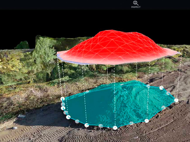
1. Point Cloud Data
One of the most exciting export options is the ability to generate and export point cloud data. Point clouds provide a three-dimensional representation of the surveyed area, capturing the precise location of objects and their attributes. This detailed data can be incredibly valuable for a wide range of construction applications.
2. Digital Terrain Models (DTMs)
In addition to point clouds, drone mapping software allows users to export Digital Terrain Models (DTMs). DTMs represent the land surface and its elevation data accurately. These models enable engineers, architects, and construction professionals to visualize the topography of the area, aiding in the design and planning of projects. With a clear understanding of the terrain, potential challenges can be identified and addressed early on, saving both time and resources.
3. 3D Models
Another exciting export option offered by drone mapping software is the ability to generate and export 3D models of the mapped area. These models provide an immersive and realistic representation of the terrain, enabling users to explore and analyze the environment in great detail. The possibilities are endless.
Seamless Integration: Exporting for Cross-Usage
One of the most significant advantages of drone mapping software is its compatibility with various other software programs commonly used in different industries. The export options provided by these platforms ensure that data can be shared in the format needed for seamless integration with other tools. Let’s explore some of the software programs that can easily incorporate drone-collected geospatial data:
1. ProCore
ProCore, a popular construction management software, can effortlessly integrate drone mapping data. By exporting the data in the required format, construction teams can leverage the power of accurate geospatial information during the planning, construction, and maintenance phases of a project. From site analysis to progress tracking, the integration of drone data with ProCore enhances project efficiency and minimizes errors.
2. Bluebeam
Bluebeam, a leading software solution for the construction industry, also readily accommodates drone mapping data. By exporting data in a compatible format, architects and engineers can seamlessly incorporate geospatial information into their designs, improving accuracy and reducing conflicts. Bluebeam’s powerful tools complement the detailed data collected by drones, empowering construction professionals to make more informed decisions.
3. Revit and CAD Systems
Revit, a Building Information Modeling (BIM) software, and various Computer-Aided Design (CAD) systems can also integrate drone mapping data effortlessly. By exporting data in the appropriate format, engineers can incorporate geospatial information into their models, enhancing the accuracy and precision of their work. From site analysis and clash detection to visualization and rendering, the integration of drone data with Revit and CAD systems revolutionizes the design process.
Export Flexibility: Maximizing the Value of Drone Mapping Data
What sets drone mapping software apart is the unparalleled export flexibility it offers. Users of these platforms have access to a broad range of export functions, ensuring that their geospatial data can be utilized to its fullest potential. Whether it’s sharing basic images, detailed point clouds, precise DTMs, or immersive 3D models, the possibilities are endless. This export flexibility allows drone mapping clients to extract maximum value from their data, facilitating collaboration between different teams, departments, and downstream applications.
Conclusion
The power of exporting drone mapping data cannot be overstated. By providing users with a vast array of export options, drone mapping software empowers industries like construction, to leverage geospatial information effectively. From basic orthomosaic maps to advanced 3D models and point clouds, the ability to seamlessly integrate drone data with common software programs unlocks endless possibilities for collaboration, design, and analysis. Embrace the potential of exporting drone mapping data and unlock the true value of your geospatial information.

0 Comments