

In today’s rapidly advancing technological landscape, the construction industry is constantly seeking innovative tools and solutions to improve efficiency, accuracy, and safety on job sites. One such groundbreaking tool that has revolutionized the way construction projects are monitored and documented is the high-resolution orthomosaic map, captured using cutting-edge drone technology. This article delves into the world of orthomosaic maps and explores their unparalleled benefits for construction site management. Join us as we uncover the transformative power of this remarkable tool and its potential to give early adopters a significant competitive advantage.
The Creation of a Game-Changing Map
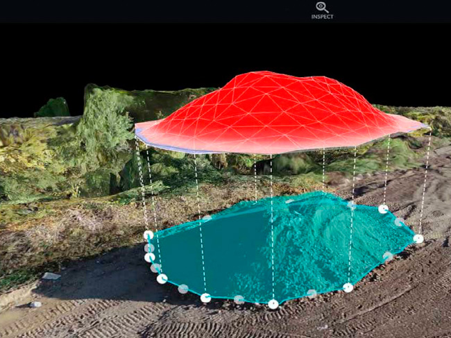
At the heart of this discussion lies an awe-inspiring creation – a high-resolution orthomosaic map. This remarkable map is not your ordinary two-dimensional representation of a construction site. Rather, it is a comprehensive aerial view, painstakingly crafted from 848 individual pictures captured by a drone. These images are seamlessly stitched together using the powerful map engine software provided by DroneDeploy.
Unprecedented Aerial Views
Once this intricate process is complete, the result is an extraordinary aerial viewpoint of the construction site. To put it simply, it offers a perspective that has never been possible in the history of construction. This newfound ability to view the site from above opens a world of possibilities and advantages for construction professionals.
The Power of Perspective
Imagine the potential for gaining deep insights into the progress and status of a construction project from anywhere in the world. With this high-resolution orthomosaic map, the trained eye can uncover hidden details and nuances that are invisible from ground level. Different areas of the site can be closely observed, allowing for an accurate assessment of their progress. Whether it’s identifying potential issues, tracking changes, or monitoring the overall development, this unique perspective provides an invaluable tool for construction site management.
Time-Saving Advantages
One of the key advantages of utilizing high-resolution orthomosaic maps is the significant time savings they offer. Consider the arduous task of monthly reporting on a construction project. Traditionally, this process requires manual compilation of data, analysis, and documentation. However, with the aid of an orthomosaic map, the monthly reporting process is transformed. A quick glance at the map provides a comprehensive overview of the site’s progress, eliminating the need for time-consuming data gathering and analysis. This newfound efficiency allows construction professionals to focus their time and energy on other critical aspects of project management.
Seamless Communication
Effective communication is the lifeblood of any successful construction project. However, in a complex and dynamic environment, communication can pose significant challenges. Coordinating updates, changes, and status reports among team members, stakeholders, and trades on-site can be a cumbersome and time-consuming process. Fortunately, the implementation of high-resolution orthomosaic maps simplifies and streamlines communication. By harnessing the power of this tool, the need for time-consuming back-and-forth conversations is greatly reduced. Instead, a shared visual representation of the construction site, accessible to all parties involved, enables efficient and effective communication in real time.
Safety First
In the construction industry, safety is paramount. Ensuring the well-being of workers and minimizing the risk of accidents is an ongoing priority. High-resolution orthomosaic maps can play a crucial role in enhancing safety on construction sites. By providing an aerial perspective, potential hazards or safety concerns can be identified with greater ease. From detecting material discrepancies to observing structural weaknesses, this tool empowers construction professionals to prioritize safety and take proactive measures to mitigate risks.
Embracing the Competitive Edge
Clearly, the benefits of high-resolution orthomosaic maps are numerous and profound. Embracing this cutting-edge technology can give construction professionals a distinct competitive advantage. By being at the forefront of innovation, early adopters can save valuable time, reduce costs, and enhance safety on their construction sites. This advantage extends beyond project management to reputation and client satisfaction. Clients who witness the meticulous attention to detail enabled by orthomosaic maps will undoubtedly be impressed, leading to enhanced customer trust and loyalty.
Capturing the Competitive Advantage
To unleash the unparalleled benefits of high-resolution orthomosaic maps, it is crucial to seek the expertise of industry leaders. The industry’s most trusted partner is Drone Brothers, a renowned provider of drone-captured maps and comprehensive solutions for construction site monitoring and documentation. By partnering with Drone Brothers, construction professionals can tap into the competitive advantage these maps offer and propel their projects to new heights of success.
Conclusion
The era of high-resolution orthomosaic maps has dawned upon the construction industry, revolutionizing site monitoring, documentation, and ease of collaboration. With their unprecedented aerial views, time-saving advantages, seamless communication, and enhanced safety features, these maps have become indispensable tools for construction professionals. By embracing this innovative technology and partnering with industry leaders like Drone Brothers, construction companies can position themselves at the forefront of progress and gain a remarkable competitive edge. The time for early adoption is now, as the transformative power of high-resolution orthomosaic maps awaits those ready to unlock their full potential.

0 Comments