Overlay maps from drone imagery revolutionize construction site planning and monitoring by comparing progress to plans for early issue detection.
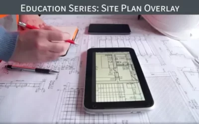
Overlay maps from drone imagery revolutionize construction site planning and monitoring by comparing progress to plans for early issue detection.
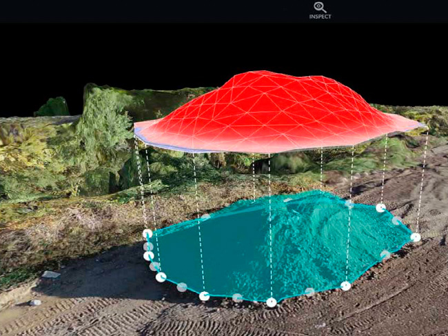
Our stockpile measurements, analytics, and cut-fill analysis capabilities are a game changer. Drone Brothers can help you streamline surveying, estimating and reporting. Combined with our advanced digital platform, we can provide you with the data you need to accurately measure earth-moving needed to reach finished grade. Helping you win bids, keep projects on schedule, and the entire project team updated on progress. Here are a few key ways that Drone Brothers can help your project with stockpile management.
Accurate volumetric measurements: Drones can be equipped with sensors that allow them to capture high-resolution imagery and data that can be used to create accurate 3D models of stockpiles. This allows for precise volumetric measurements, which can help to ensure that inventory levels are accurate and up-to-date.
Efficient inventory tracking: Drones can be used to collect data on a regular basis, providing up-to-date information on the status of stockpiles. This can help construction teams to track inventory levels more efficiently and to ensure that they have the materials they need on hand when they need them.
Improved safety: By using drones, construction teams can avoid the need for manual measurement and monitoring, which can be hazardous and time-consuming. This can help to reduce the risk of accidents and injuries on site.
Cost savings: By providing accurate and up-to-date information on stockpile levels, drones can help construction teams to avoid overstocking or under-stocking, which can result in cost savings. This can also help to reduce waste and ensure that materials are used efficiently.
Overall, the use of drones for stockpile management can help construction teams to monitor inventory levels more efficiently, accurately, and safely. By providing up-to-date information on stockpiles, drones can help to ensure that construction projects stay on track and on budget.
The real cost to you is immeasurable when money is lost on inaccurate and inefficient inventory tracking.
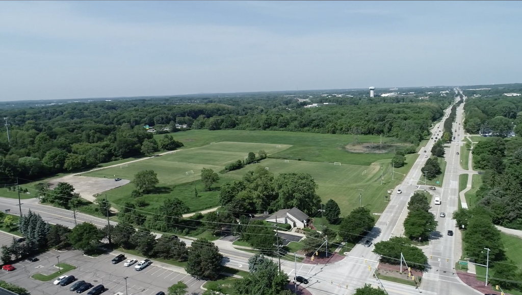
Site selection in the construction process is crucial. Mistakes or oversights can have a ripple effect in many ways. Aerial assets from Drone Brothers can get you off to a good start. Rather than looking at outdated Google Maps, drone pilots are able to fly a prospective site without you having to leave the office while still getting a detailed, up-to-date view of the property your considering for your next job site. Here are a few of the advantages of having Drone Brothers fly your site before beginning a project.
Higher resolution imagery: Drones can capture high-resolution imagery of potential construction sites, providing more detailed information about the site’s topography, vegetation, and other features that can impact the construction process. Google Maps imagery may not be as up-to-date or detailed. One can see the vast potential in showing a high resolution image. No eye squinting or ambiguity here.
Real-time data: Drones can capture real-time data, providing construction teams with up-to-date information about the site. Google Maps imagery may be several months or even years old, and may not reflect recent changes to the site. Try to imagine your embarrassment when a developer or investor realizes that the images you’re showing them have been drastically changed since or even before the onset of their plans, forcing them to rethink their investment of precious time and money.
3D modeling: Drone mapping can create 3D models of construction sites, providing more detailed information about the site’s elevation, slope, and other features. Google Maps does not offer 3D modeling.
Customized data: Drones can capture customized data based on the specific needs of the construction project, such as soil quality or the location of underground utilities. Google Maps provides general data that may not be tailored to the specific needs of a construction project.
Safety: Unlike Google Maps which can’t accurately assess the safety of an area, whether due to environmental factors such as uneven surfaces, or hazardous conditions from recent inclement weather, Drone Brothers mapping analytics can get the job done and assure you that you won’t be putting anyone on your team in harm’s way with a poorly selected site.