

Planning, preconstruction, construction and close-out are the four primary phases for any particular construction project. Some break construction project management into seven key stages: design, pre-construction, procurement, construction, commissioning, owner occupancy and project closeout. However you look at it, the objectives for each phase are unique.
Whether you’re building a small retail center or a massive industrial facility, each phase of the project presents opportunities to save time and money by identifying efficiencies and opportunities to keep moving the project forward. Many project managers and superintendents don’t realize just how powerful drones are in helping pinpoint these efficiencies and opportunities.
Here are just a few of the ways drones support each phase of a construction project.
Planning
Before any machine starts moving earth or building begins, every project starts with a plan. Any construction job plan that doesn’t make use of drone technology is missing out on a huge time saver. Here are 3 ways drones can help in the planning phase:
- Site Selection: As the project starts to develop, you’ll start the process of finding a site for your job. Without leaving your office, hiring a drone company to fly potential land will allow you to see the land in a way much more detailed than you could in person.
- Topographic Maps: Drone mapping technology allows you to see your job site, or potential job site in ways you normally can’t. View elevation, vegetation and other key aspects of the site without having to visit the site yourself.
- Zoning: Once you identify the land for the project, you’ll want to get in front of local zoning groups to take the next step into pre-construction. Drones can help you get ahead of potential concerns a zoning committee by basically, bringing the site to them.
Pre-Construction
As you move closer to construction, this phase is all about developing an air-tight plan and strategy for your project. Usually during this phase detailed schematics are drafted up and the vision of your project starts to become clear. Here’s how drones can help you make that vision crystal clear for all of your project stakeholders:
- Photos & Videos: Capture pre-construction photos and videos that can be used in your planning materials. This will help everyone visualize the key locations and areas of your job site.
- Site Plan Overlay: Now that the site is selected and you’ve got a plan in place, we’ll overlay your schematics and blueprints on top of the aerial map that we create. This will help you and your team better visualize the project.
- Documentation & Legal Protection: Drones can help you document the job site and all the main road conditions leading to it before you start. This will allow you the ability to understand your crews impact on the surrounding areas.
Construction
The job is underway. Not only is it critical to keep the job moving as efficiently and safely as possible, but keeping your project stakeholders informed, is critical. From your boss, to your client, drones can help you effectively communicate how the project is going by letting the photos, videos and maps speak for themselves.
- Progress Photos & Videos: Keep your stakeholders informed of progress of the job.
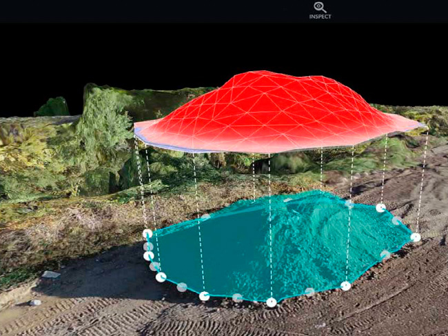
- Stockpile Measurements: Dealing with huge stockpiles of materials? Capture stockpile measurements without having to leave the trailer. If we’re already capturing progress photos, this is a simple add-on that will save you time and money
- Inspections: Using drones will keep you from putting people at risk to inspect dangerous areas of the job.
- Site Monitoring (Orthomosaic Mapping): Complete views of the job site that allow you to zoom in and out in spectacular details. Think of these as google maps on steroids!
- Software Integrations: Connect our drone assets with your project software. For instance, import up-to-date site plans to your drone maps to compare designs with reality. Drone maps can be integrated with AutoCAD and other CAD software.
Close Out
Obviously, once it’s time to put the final touches on the job, the reality is that there are often many stakeholders interested in the job progress. Capture one last drone video to show off the finished work. Supplement it with interior video as well to give a complete, 360-degree, inside and out view of the project.
This will not only be a great piece of content to share with the client, these assets can also be used in all of your marketing and social media.

0 Comments