
Drones have become an essential tool for construction sites, particularly for 3D mapping. Here are 10 ways drones help with 3D mapping for construction sites:
- High-Resolution Aerial Imagery: Drones capture detailed, high-resolution images from various angles, allowing for accurate 3D modeling of the entire construction site.
- Real-Time Data Collection: Drones can quickly survey a construction site and provide real-time data, reducing the time needed to generate accurate 3D maps.
- Cost-Effective Surveys: Traditional surveying methods can be expensive and time-consuming, but drones provide a more cost-effective solution for 3D mapping, reducing the need for heavy equipment and personnel.
- Efficient Terrain Modeling: Drones use photogrammetry to capture the topography of a construction site, producing detailed terrain models that can be used to plan and monitor the site’s development.
- Topographic Mapping: Drones can generate 3D models that show the contours, elevations, and slopes of the site, which are crucial for construction planning and design.
- Reduced Risk to Personnel: By using drones for mapping, the need for personnel to work in potentially dangerous or hard-to-reach areas is minimized, improving safety on the job site.
- Progress Tracking: Drones can provide frequent and accurate 3D maps that allow construction managers to track the progress of a site, identify issues early, and ensure that work is being done according to plan.
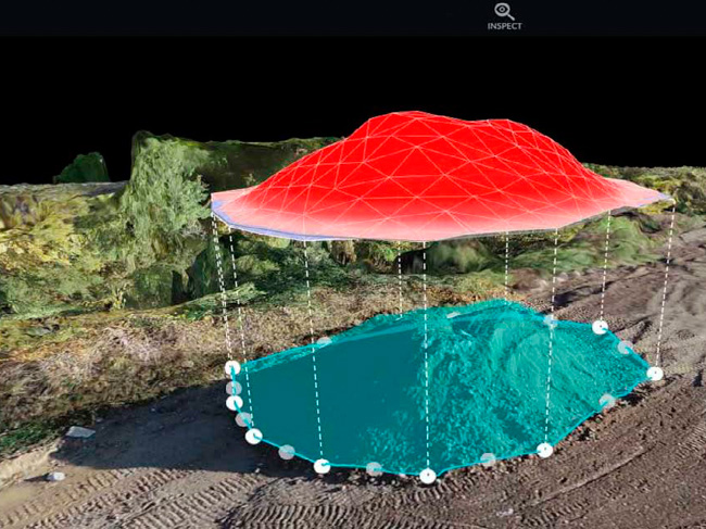
- Volume Measurements: Drones can calculate the volume of materials, such as earth or construction materials, that have been excavated or added to a site, aiding in material management and project planning.
- Site Analysis and Design: With 3D mapping, drones can provide data that architects and engineers can use to make design adjustments, assess the feasibility of certain elements, or check alignment with initial plans.
- Geospatial Data Integration: Drones can be integrated with Geographic Information Systems (GIS) and Building Information Modeling (BIM) software to enhance the accuracy and functionality of 3D models, aiding in collaborative design and decision-making.
Overall, drones streamline the process of 3D mapping for construction sites, improving efficiency, safety, and accuracy throughout the project lifecycle.

0 Comments